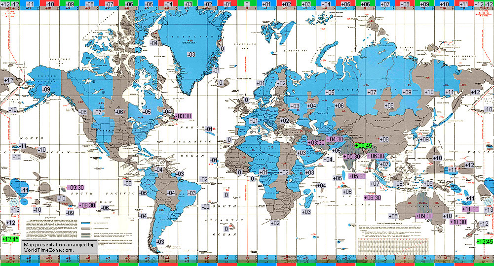
History of the Standard Time Zone charts of the World from 1894 to present
map presentation arranged by World Time Zone
(WorldTimeZone map may not be used or reproduced without permission
or credit to WorldTimeZone.com)
|
History of the Standard Time Zone charts of the World and the International Date Line
(presentation arranged by WorldTimeZone, World Time Zone)
(WorldTimeZone map may not be used or reproduced without permission
or credit to WorldTimeZone.com)
|
| Date |
Notes, regulations, decisions, maps |
More |
| 1844 |
International Date Line in 1844
Philippines kept the Western or American date;
Alaska was a Russian territory (Russian America) until 1867 keeping the same date as at home (Eastern or Asiatic date) ;
Kingdom of Samoa was keeping Eastern (Asiatic) dates;
The Cook Islands was keeping Eastern (Asiatic) dates;
|
|
| 1845 |
International Date Line in 1845
Philippines changed its date to the Eastern (Asiatic) side;
Alaska was a Russian territory (Russian America) until 1867 keeping the same date as at home (Eastern or Asiatic date) ;
Kingdom of Samoa was keeping Eastern (Asiatic) dates;
The Cook Islands was keeping Eastern (Asiatic) dates;
|
|
| 1845-1867 |
International Date Line in 1845-1867
Captain Morrell falsely reported the discovery of a small islands northwest of the Hawaii (Morrell and Byers Islands);
Alaska was a Russian territory (Russian America) until 1867 keeping the same date as at home (Eastern or Asiatic date) ;
Kingdom of Samoa was keeping Eastern (Asiatic) dates;
The Cook Islands was keeping Eastern (Asiatic) dates;
|
|
| 1867-1892 |
International Date Line in 1867-1892
Alaska changed from the Julian calendar, Asiatic date to the Gregorian calendar, American date in 1867;
|
|
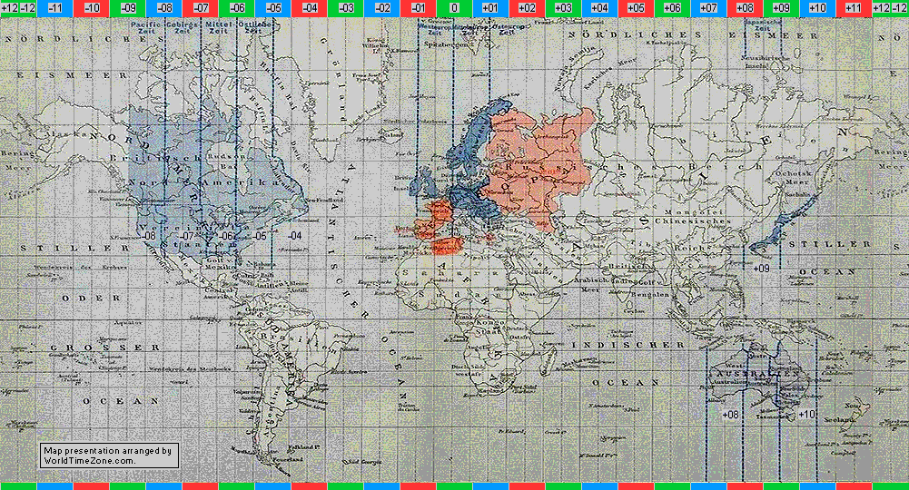
| 1894-1897 |
Standard Time Zone chart of the World in 1894-1897
Source map from the Brockhaus Konversations-Lexikon, Einheits Und Ortszeit- map presentation arranged by WorldTimeZone
|
|
| 1892-1899 |
International Date Line in 1892-1899
Kingdom of Samoa changed its Eastern (Asiatic) date to the Western (American) date on Monday, 4 of July 1892;
|
|
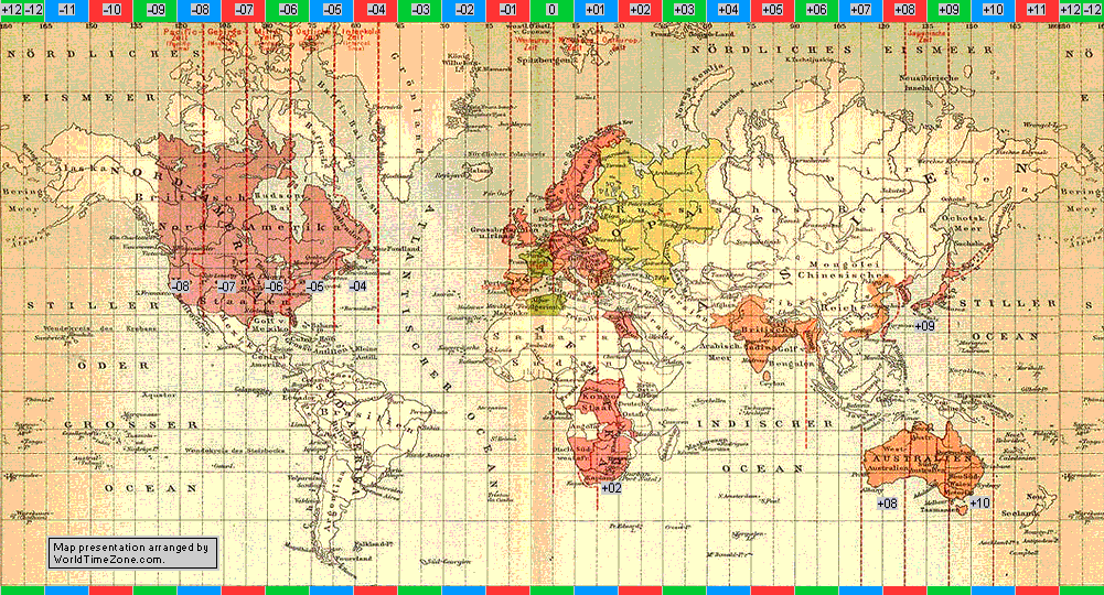
| 1905 |
Standard Time Zone chart of the World in 1905
Source map from the Brockhaus Konversations-Lexikon, Einheits Und Ortszeit- map presentation arranged by WorldTimeZone
|
|
| 1899- 1910 |
International Date Line in 1899- 1910
Cook Islands changed its date from the Eastern (Asia, New Zealand, Australia) side to the Western (American) side on Christmas day 1899;
|
|
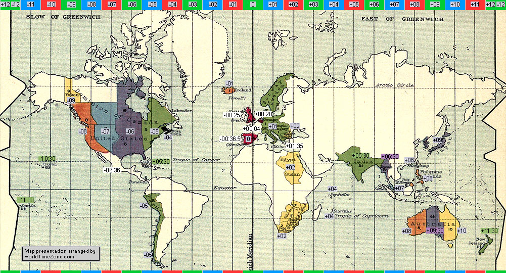
| 1910 |
Standard Time Zone chart of the World in 1910
Source map from the Ball's Popular Guide to the Heavens, The London Geographical institute- map presentation arranged by WorldTimeZone
|
|
| 1910-1995 |
International Date Line in 1910-1995
Morrell and Byers Isl. were removed, returning the International Date Line to the 180 meridian all the way to the equator and Kiribati-Fiji-Samoa,
however these "fake islands" continued to appear on different charts (maps, globes) until 1950-1970 by different publishers.
|
|
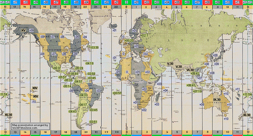
| 1917 |
Standard Time Zone chart of the World in 1917
Source map from the Ministere de la Marine, Service Hydrographique, Planisphere des fuseaux horaires, France- map presentation arranged by WorldTimeZone
|
|
| 1919-1925 |
Standard Time Zone chart of the World in 1919-1925
Source map from the Department of Cartography, St. Petersburg State University, academician Y.M. Shokalsky, Russia- map presentation arranged by WorldTimeZone
|
|
| 1920 |
Standard Time Zone chart of the World in 1920
Source map from the Encyclopedia Britannica, Department of The Navy, Hydrographic Office- map presentation arranged by WorldTimeZone
|
|
| 1921-1923 |
Standard Time Zone chart of the World in 1921-1923
Source map from the Department of The Navy, Hydrographic Office- map presentation arranged by WorldTimeZone
|
|
| 1923 |
Standard Time Zone chart of the World in 1923
Source map from the Instituto Meteorologico Nacional, Planisferio de Los Husos Horarios, Uruguay- map presentation arranged by WorldTimeZone
|
|
| 1927 |
Standard Time Zone chart of the World in 1927
Source map from the Lindbergh Chart - Time zone chart of the world, Hydrographic Office, Washington, D.C., United States- map presentation arranged by WorldTimeZone
|
|
| 1940 |
Standard Time Zone chart of the World in 1940
Source map from the Atlas of the World, Map of Time Zones, Russia- map presentation arranged by WorldTimeZone
|
|
| 1941-1943 |
Standard Time Zone chart of the World in 1941-1943
Source map from the Department of The Navy, Hydrographic Office, Time Zone Chart Of The World No 5192, 12th Edition- map presentation arranged by WorldTimeZone
|
|
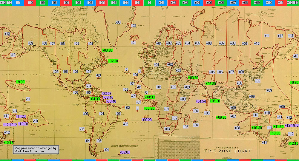
| 1943 |
Standard Time Zone chart of the World in 1943
Source map from the War Department, Hydrographic Office, Time Zone Chart, The New York Public Library- map presentation arranged by WorldTimeZone
|
|
| 1944 |
Standard Time Zone chart of the World in 1944
Source map from the Department of The Navy, Hydrographic Office, Time Zone Chart Of The World, The New York Public Library- map presentation arranged by WorldTimeZone
|
|
| 1952 |
Standard Time Zone chart of the World in 1952
Source map from the "The Citizen's Atlas of the World", by John Bartholomew, Edinburgh Geographical Institute- map presentation arranged by WorldTimeZone
|
|
| 1958 |
Standard Time Zone chart of the World in 1958
Source map from the Department of The Navy, Hydrographic Office, Standard Time Chart Of The World No 5192, 19th Edition, The New York Public Library- map presentation arranged by WorldTimeZone
|
|
| 1960 |
Standard Time Zone chart of the World in 1960
Source map from the Department of The Navy, Hydrographic Office, Standard Time Chart Of The World No 5192, 20th Edition, The New York Public Library- map presentation arranged by WorldTimeZone
|
|
| 1968-1970 |
Standard Time Zone chart of the World in 1968-1970
Source map from the Department of The Navy, Hydrographic Office, Standard Time Zone Chart Of The World No 5192, 21th Edition, The New York Public Library- map presentation arranged by WorldTimeZone
|
|
| 1971-1974 |
Standard Time Zone chart of the World in 1971-1974
Source map from the Standard Time Zone Chart Of The World- map presentation arranged by WorldTimeZone
|
|
| 1975 |
Standard Time Zone chart of the World in 1975
Source map from the Standard Time Zone Chart Of The World- map presentation arranged by WorldTimeZone
|
|
| 1976-1978 |
Standard Time Zone chart of the World in 1976-1978
Source map from the Department of The Navy, Hydrographic Office, Standard Time Zone Chart Of The World No 5192, 22nd Edition, The New York Public Library- map presentation arranged by WorldTimeZone
|
|
| 1980 |
Standard Time Zone chart of the World in 1980
World Time Zone- map presentation arranged by WorldTimeZone
|
|
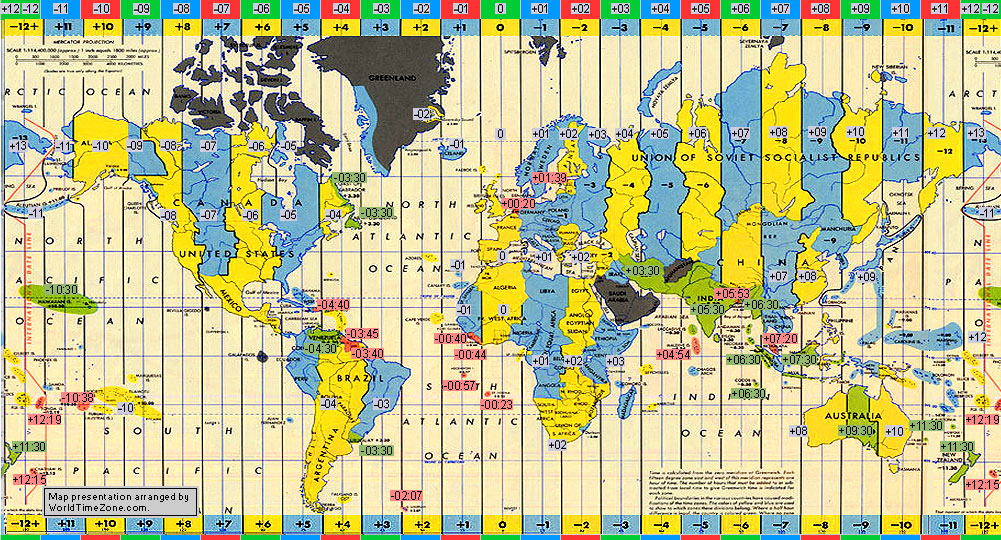
| 1992 |
Standard Time Zone chart of the World in 1992
Source map from the Defence Mapping Agency, Standard Time Zone Chart Of The World, 25th Edition- map presentation arranged by WorldTimeZone
|
|
| 1994 |
Standard Time Zone chart of the World in 1994
World Time Zone- map presentation arranged by WorldTimeZone
|
|
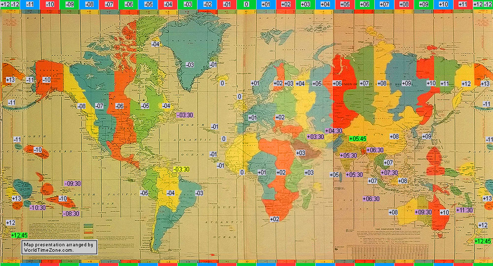
| 1995-2011 |
International Date Line in 1995-2011
Kiribati introduced a change of date for its eastern half (Phoenix UTC-11:00 and Line Islands UTC-10:00 observed American dates) on 31 December 1994.
International Date Line was moved eastwords almost reaching the 150w meridian to observe the same Eastern (Asian) date throughout its territory.
Phoenix Islands, Kiribati changed its time zone UTC-11:00 to UTC+13:00.
Line Islands (Kiritimati), Kiribati changed its time zone UTC-10:00 to UTC+14:00.
|
|
| 1997 |
Standard Time Zone chart of the World in 1997
World Time Zone- map presentation arranged by WorldTimeZone
|
|
| 2001 |
Standard Time Zone chart of the World in 2001
World Time Zone- map presentation arranged by WorldTimeZone
|
|
| 2005 |
Standard Time Zone chart of the World in 2005
World Time Zone- map presentation arranged by WorldTimeZone
|
|
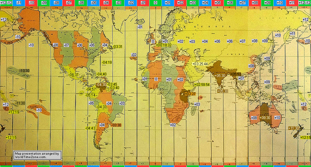
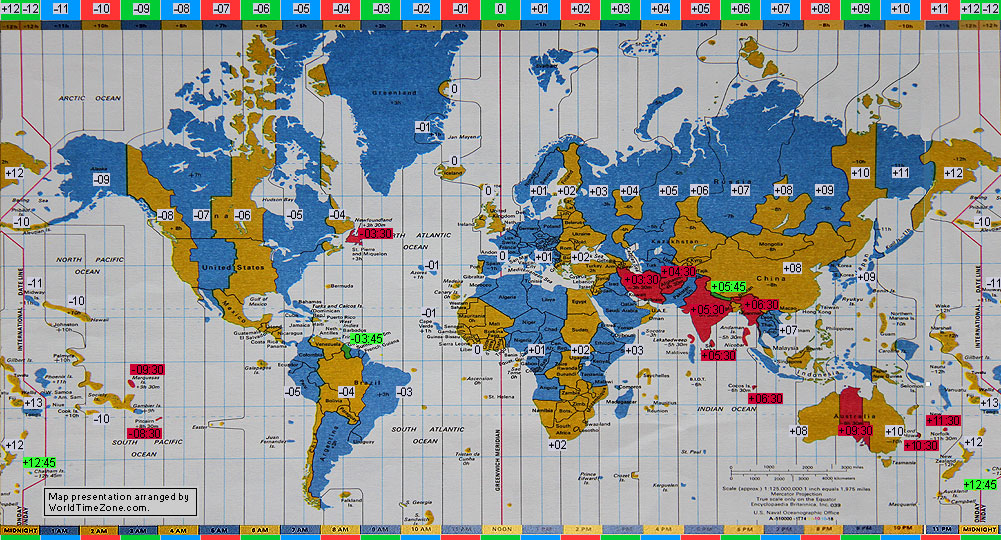
| 2010-03-28 |
Standard Time Zone chart of the World in 2010-03-28
World Time Zone- map presentation arranged by WorldTimeZone
|
|
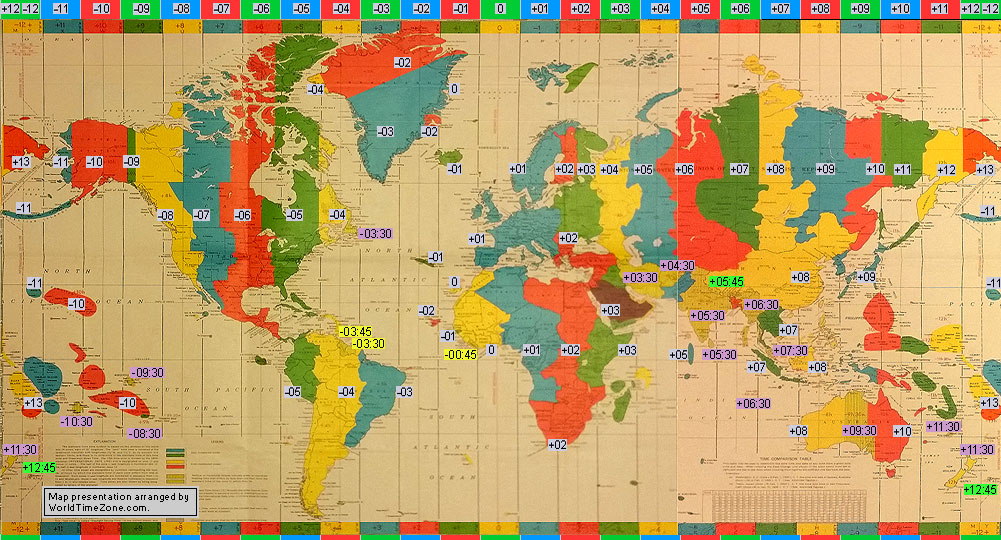
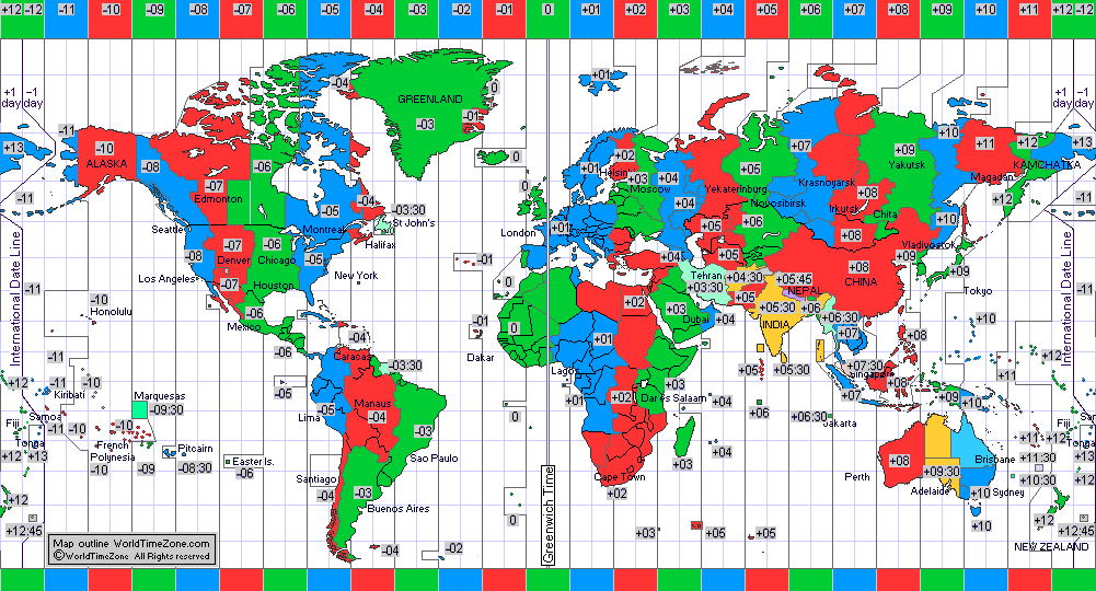
| 2011 to now |
International Date Line from 2011 to now
Samoa (Apia) and Tokelau (Fakaofo) changed the Western (American) date to the Eastern (Asiatic) date at midnight on Thursday, 29 December 2011, which was followed by Saturday, 31 December 2011;
|
|
| 2011-11 |
Standard Time Zone chart of the World in 2011-11
World Time Zone- map presentation arranged by WorldTimeZone
|
|
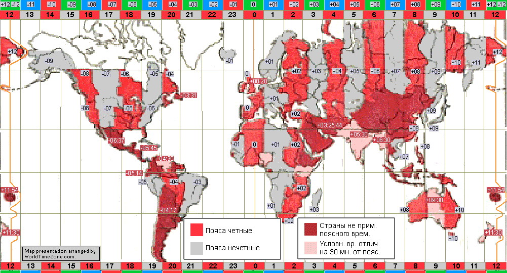
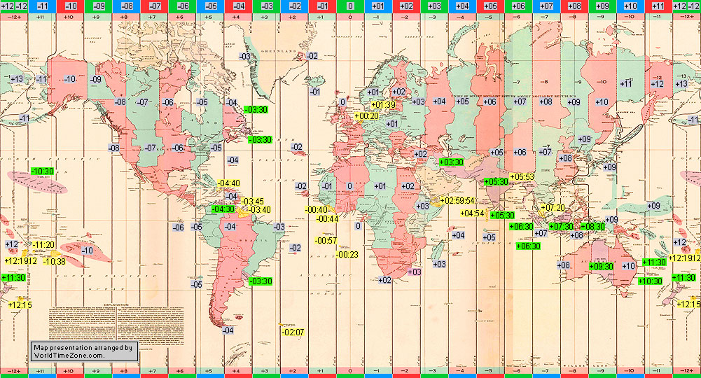
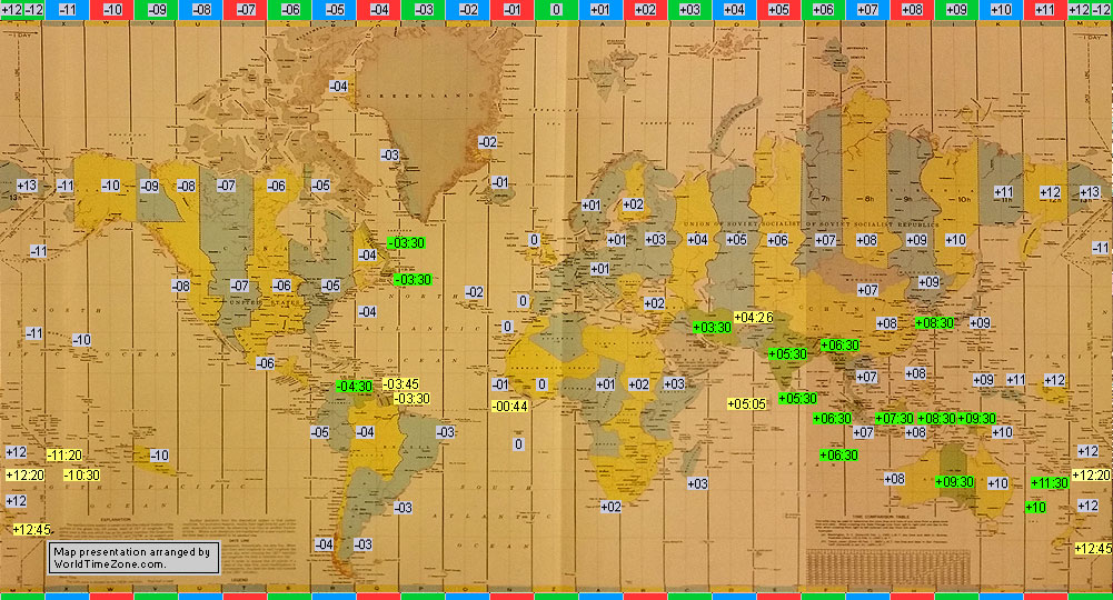
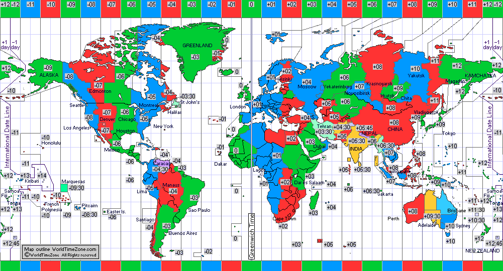
| 2016-11 |
Standard Time Zone chart of the World in 2016-11
World Time Zone- map presentation arranged by WorldTimeZone
|
|
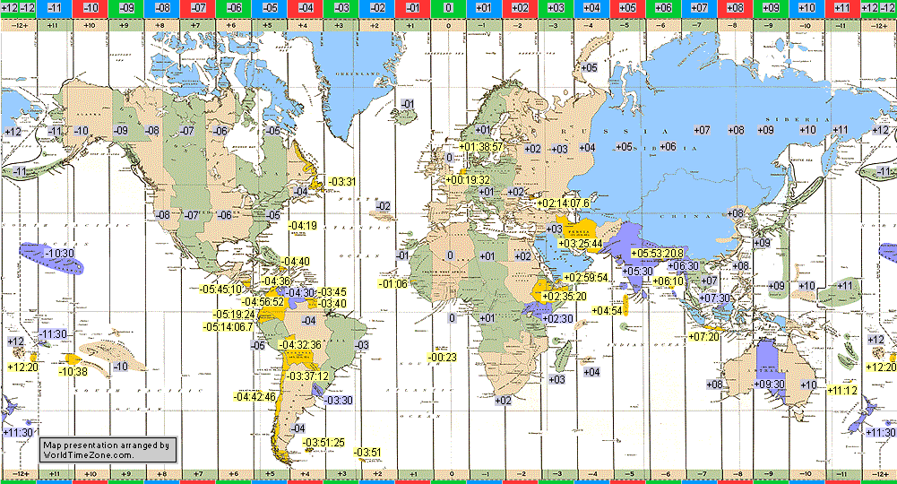
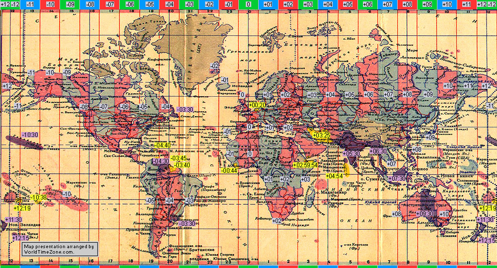
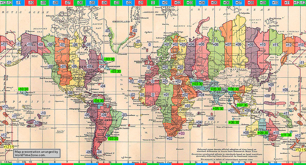
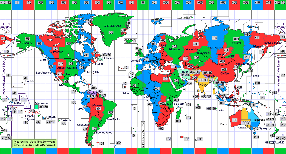
| 2018-11 |
Standard Time Zone chart of the World in 2018-11
World Time Zone- map presentation arranged by WorldTimeZone
|
|
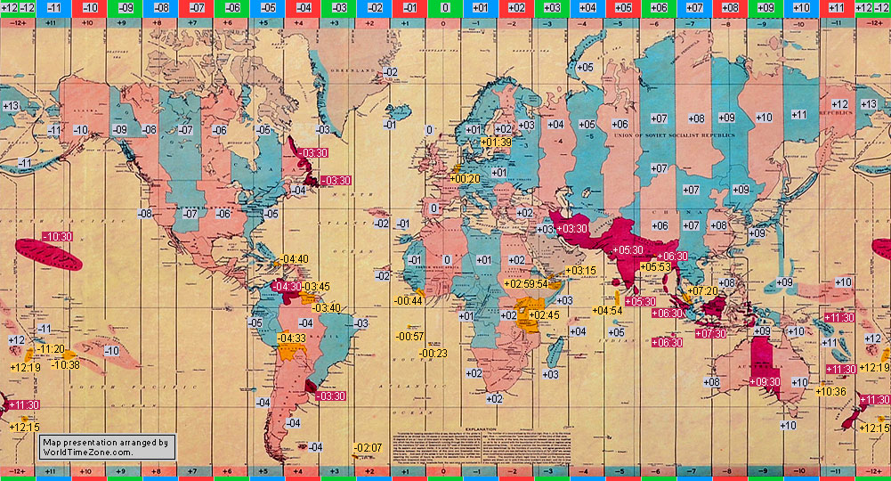
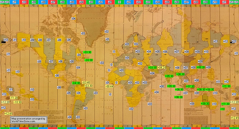
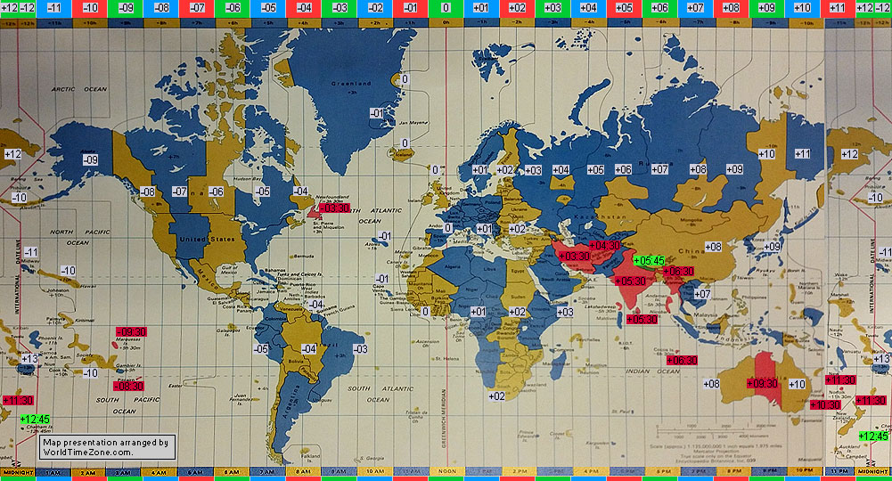
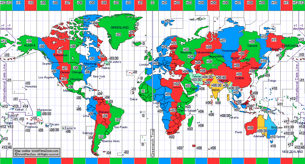
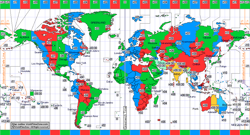
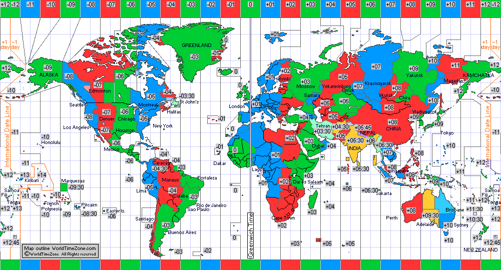
| 2021-03 |
Standard Time Zone chart of the World in 2021-03
World Time Zone- map presentation arranged by WorldTimeZone
|
|
Back to History of the Standard Time Zone charts of the World from 1894 to present
Back to History of the Daylight Saving Time (DST) / Summer Time from 1916 to present
Back to History of the International Date Line from 1844 to present
|
* If you have further updates or can provide corrections- please send us
Email with
credible Web referral source to verify your information.
|
|
|